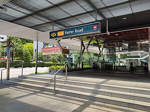
Farrer Road MRT station
CC20
Farrer Road 花拉路 ஃபேரர் சாலை | |||||||||||
|---|---|---|---|---|---|---|---|---|---|---|---|
| Mass Rapid Transit (MRT) station | |||||||||||
 Exit B of Farrer Road station | |||||||||||
| General information | |||||||||||
| Location | 71 Farrer Road Singapore 261006 | ||||||||||
| Coordinates | 1°19′02″N 103°48′27″E / 1.317319°N 103.807431°E | ||||||||||
| Operated by | SMRT Trains Ltd (SMRT Corporation) | ||||||||||
| Line(s) | |||||||||||
| Platforms | 2 (1 island platform) | ||||||||||
| Tracks | 2 | ||||||||||
| Connections | Bus, Taxi | ||||||||||
| Construction | |||||||||||
| Structure type | Underground | ||||||||||
| Platform levels | 1 | ||||||||||
| Accessible | Yes | ||||||||||
| History | |||||||||||
| Opened | 8 October 2011 | ||||||||||
| Electrified | Yes | ||||||||||
| Previous names | Farrer, Woollerton[1] | ||||||||||
| Passengers | |||||||||||
| June 2024 | 4,576 per day[2] | ||||||||||
| Services | |||||||||||
| |||||||||||
| |||||||||||
Farrer Road MRT station is an underground Mass Rapid Transit (MRT) station on the Circle line, located along the boundary of Farrer Court (Bukit Timah) and Tyersall (Tanglin) planning areas, Singapore. It is built underneath Farrer Road, the thoroughfare which gives the station its name, and is located near the Farrer Gardens Estate.
Farrer Road was named after Roland John Farrer, who was President of the Municipal Commissioners from 1919 to 1931. To avoid confusion with Farrer Park MRT station, the station was renamed to Farrer Road on 11 January 2007. The station serves the nearby Farrer Gardens housing estate, many condominiums and private homes, schools, and places of worship.
Farrer Road station is built underneath its namesake road, between the junctions of Empress Road and Woollerton Park.
History
[edit]
The junction of Farrer Road and Empress Road had been realigned from 1 December 2004, this marks the start of construction of Farrer Road MRT station. The station was renamed from Farrer to Farrer Road on 11 January 2007.
On 24 May 2008, a section of Cornwall Gardens above a section between Holland Village and Farrer Road stations along the Circle line collapsed, creating a 3 metre deep hole. No one was injured, but some of the households lost their access to cable TV and Internet, as well as the water supply. This is the third road that caved in during the construction of the Circle line.[3]
It is often mistaken for Farrer Park MRT station; as such, station masters have put up a sign informing both locals and tourists that Farrer Road MRT is not the one located near the famous Mustafa Centre that they likely wanted to visit.[4]
Art in Transit
[edit]The artwork featured in this station under the Art in Transit programme is Art Lineage by Erzan Adam. In this community project, using lines as a key element to emphasise unity in art and in the community, members of the public were invited to paint coloured lines in any way they liked over three canvasses. The artist then digitised and overlayered the images to create a single piece, which is now displayed on the lift shaft in the station.[5]
References
[edit]- ^ "FINALISED NAMES FOR CIRCLE LINE (CCL) STAGES 4&5 STATIONS". www.lta.gov.sg. Archived from the original on 18 December 2006.
- ^ "Land Transport DataMall". Datamall. Land Transport Authority. Archived from the original on 14 August 2024. Retrieved 14 August 2024.
- ^ Ee Wen Wei, Jamie (25 May 2008). "Circle Line work causes cave-in off Holland Road". AsiaOne. Retrieved 14 August 2022.
- ^ "Here are the most annoying station names on the Singapore MRT network | CityMetric". www.citymetric.com. Retrieved 11 December 2018.
- ^ Martin, Mayo. "Circle Line Art! The final destination(s)! A sneak peek!". For Art's Sake!. TODAYonline Blogs. Archived from the original on 27 December 2011. Retrieved 11 October 2011.
External links
[edit] Media related to Farrer Road MRT Station at Wikimedia Commons
- Official website

